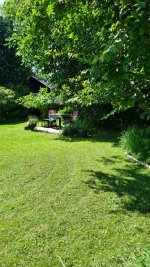
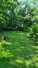
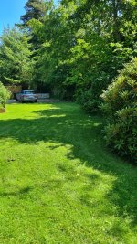
Wie sieht Eure Umgebung aus? Wo läuft GPS und wo sind die Grenzen des Systems?

Würde das Rover Board via USB an den Laptop stecken mit GPS+LR Antenne und dann mal wild übers Grundstück paar Positionen testen ob da ein Fix ankommt.
Gerade mal mögliche Problemstellen durchgehen, zum einen Unter Bäumen aber auch nahe an Hauswänden oder anderen großen Hindernisse.
Direkt an der Garage/Hütte könnte es auch problematisch werden falls du darunter/nahe mähen willst.

Aber die GPS Antenne sieht gut aus, wenn rechts nicht direkt ein Haus daneben steht.
Long Rang Antenne sicherlich nicht optimal aber die Signale gehen meist auf einem normalen Grundstück so ziemlich durch alles durch, bei mir kommt die auch komplett durch ein Haus durch. Wenn der Rover in Float oder Invalid geht liegt es eher zu 99,9% an dem Rover GPS Signal weil der gerade sich unter Büschen oder direkt an der Hauswand bewegt.

Ob man die Haube wirklich braucht oben drauf?
Bei mir hängt die GPS Antenne seit +1 Jahr komplett im Wetter, sieht optisch immer noch gefühlt wie neu aus.

Falls du einen Ardumower baust, auf den Rover oben drauf auch so eine kleine runde Metalplatte unter die GPS Antenne platzieren.
 
Puh schon lange nicht mehr genutzt die Software aber geht die 3D Acc. nicht deutlich runter?
Sollte eigentlich auf 0.02 gehen was den 2cm entspricht die du bei Fix im Sunray hast.

50 Meter ist jedenfalls kein Fix für den Mower. 😁
 
Mit dem Ublox Center sieht man doch keinen fix für 2cm Navigation. Das sieht man nur welche und wieviel Satelliten man an der GPS Basis oder im Mower empfängt.
Ich würde jetzt mal sagen, das den Fix nur in der Sunray APP siehst, da dort die Daten vom Roboter sichtbar sind und der Roboter den fix anzeigt wenn er das Korrektursignal empfängt und aus beiden GPS Signalen dann seine Position berechnen kann.

Ich glaube im Ublox Center kann man nur sehen ob das GPS Signal gut genug ist zum berechnen seiner Position:

1688585197302.png
 
Der Standardort ist gut!

Leider weiss ich auch nicht, wie man das messtechnisch verifizieren und bewerten kann.
Ich befürchte, dass das gar nicht geht.
Die einzige Chance ist das lange laufen zu lassen und Statistiken zu erstellen.
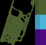
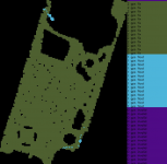
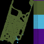
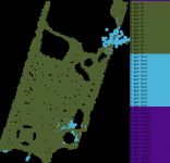
Ich habe Alfred 4 mal vormittags und nachmittags an aufeinander folgenden Tagen Heatmaps erstellen lassen.
Die sahen immer etwas anders aus:
1688625137728.png1688625177453.png1688625216289.png1688625272185.png

Was schließt man jetzt daraus?
Im allgemeinen gut, gibt aber auch Ausnahmen.

Ausser dem Wetter und den Satellitenpositionen hat sich zwischen den einzelnen Fahrten nichts geändert.

GPS ist leider nicht statisch, sondern ein hochdynamisches System, aus dem man mit RTK versucht ein sehr präzises statisches System zu machen. Das funktioniert nicht immer gleich gut.

Beste Grüße,
Chris
 
Zuletzt bearbeitet:
Der Standardort ist gut!

Leider weiss ich auch nicht, wie man das messtechnisch verifizieren und bewerten kann.
Ich befürchte, dass das gar nicht geht.
Die einzige Chance ist das lange laufen zu lassen und Statistiken zu erstellen.
Ich habe Alfred 4 mal vormittags und nachmittags an aufeinander folgenden Tagen Heatmaps erstellen lassen.
Die sahen immer etwas anders aus:
Anhang anzeigen 6768Anhang anzeigen 6769Anhang anzeigen 6770Anhang anzeigen 6771

Was schließt man jetzt daraus?
Im allgemeinen gut, gibt aber auch Ausnahmen.

Ausser dem Wetter und den Satellitenpositionen hat sich zwischen den einzelnen Fahrten nichts geändert.

GPS ist leider nicht statisch, sondern ein hochdynamisches System, aus dem man mit RTK versucht ein sehr präzises statisches System zu machen. Das funktioniert nicht immer gleich gut.

Beste Grüße,
Chris
"Der Standort ist gut!"
Meinst du jetzt mich?
 
Hi!

I have a Husqvarna auto mower for our lawn, but would like to build an ArduMower to top the fields on our farm (mow the tall grass that the cows don’t eat). Whilst I appreciate I will likely need to modify the mower to cope with larger areas, can the software be modified to cover a larger area?

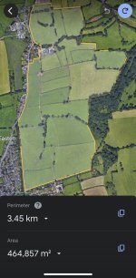
The main farm is 600 x 1200 m. Not all of it will need topping but there will be parts spread across the area that will need cutting once or twice a year. Could I set up a few adjacent ‘lawns’ within a 300 m radius and run them separately? Are there better solutions?

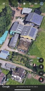
The mower would also need to pass under large farm buildings (typically 20 x 20 m) where rtk signal will be limited. 2 cm accuracy won’t be needed but will it be possible to pass under these buildings using dead reckoning, a lower accuracy rtk or another positioning method?

I won’t be trying this as my first project and was planning to build a mower for our lawn first to learn the basics!

Thanks,

Simon
 
Hi Simon,

is it possible to show some pictures of the area and the buildings to get a better feeling for the situation?

What kind of roof have the buildings? metal sheet roof?

Best regards,
Chris
 
There are some limits by creating maps, I don’t know exactly what is the maximum distance, but if I remember correctly your area ist to large for Sunray FW to covering with just one map. You can work with absolute Mode and create more then one map and switch every time coordinates by switching map
 
Thanks for your replies - really appreciated

Picture of the main area attached.

The buildings have fibre-cement roofs. Google maps location of your phone inside them is surprisingly accurate (within a meter or two), but I believe this uses mobile phone signal positioning too, not just gps.

I read that the maximum distance from the base point / 0,0 of the map is 300 m in any direction, so essentially, everything on the map has to be within a 300 m radius circle. I was wondering if there was a way around this that anyone had experience of? Is it practical to flip between alternate maps?

Does the Sunray code support other types of positioning, for example just using a boundary wire, or does a boundary wire system work based on completely different code? Is it possible to customise or alter the code once you have got experienced?

Thanks again, Simon
 
This is just another example that a guidance wire is useful even for a GPS controlled mower. I have a similar usecase underneath a carport. It is only used as a transition between two mow areas
 
Is it practical to flip between alternate maps?
It is not a big deal, sunray app supports 10map slots, your problem will be to switch position data in the app, what actually to be changed one time at initial process. In your case you will have to change it every time if you load new map, it could be not so comfortable
 
If it is known where the limitation is in the code, I guess the limitation could be changed?!

Maybe the area is not a square, then the limitation could maybe changed to a rectangle to save memory?!
 
Hi Mark
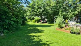
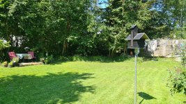
I seriously consider the Ardumower, but I'm wondering if I have too many trees in my garden for GPS RTK. In some places, the overhang is maybe 30-45 degrees from the edge of the garden to clear sky. On the other hand, most of the garden is not covered by trees. Based on the pictures, what would you recommend?
I am willing to take a chance, since the same kit can be used with the wired option (If I understood correctly).

Nice project. Best regards, Nikolaj

20230709_141139.jpg
20230709_141150.jpg
20230709_141216.jpg
20230709_141243.jpg
20230709_141357.jpg
 
Zuletzt bearbeitet:
Oben