Mein Projekt CaSSAndRA zur Steuerung des Ardumowers

Könnte man es ggf. in Zukunft so mache, dass man im einzelne Referenzpunkte auf der Perimeter (manuell) gibt, die er zum Transit verwenden kann? Dann könnte man genau beeinflussen, wo er lang fahren soll um Passagen zu überwinden.
Wenn ich irgendwann mal die Punkte editierbar mache, versuche ich dran zu denken. Die Idee ist gut... und wer keine Lust drauf hat die Fallback Lösung klassisch über den Perimeter
 
@EinEinfach : Sind die Map Daten nach einem genormten Format aufgesetzt?
Ist es das GeoJSON Format?
Oder hast du dir das selber ausgedacht?
Wenn selber ausgedacht, dann ist es vielleicht sinnvoll darüber nachzudenken, ob man das nicht auf das GeoJSON Format ändern kann.
Das würde die Möglichkeiten erweitern die Daten editierbar zu machen.
https://de.wikipedia.org/wiki/GeoJSON
https://geojson.io/
https://vector.rocks/
https://geo-json.com/

...da gibts noch einiges mehr

Ich hab das gerade zufällig gefunden.

Beste Grüße,
Chris
 
Ja, alles gut, aber wäre es nicht eine gute Idee, das GeoJSON Format zu nutzen?
Das muss man natürlich einmal stemmen, aber dann ist es standarisiert und eröffnet ganz neue 3rd Party Möglichkeiten.
Ich habe noch nicht gesucht, aber da gibt es sicherlich Konverter und Editoren, usw.
Wenn man dann noch absolute Koordinaten benutzt, kann man alles mögliche damit machen.

Ich wollte eigentlich nur eine Map in mein CAD Programm laden, und bevor ich alle Punkte händisch abtippe habe ich nach Konvertern gesucht. So bin ich schnell auf das Format gestoßen.
 
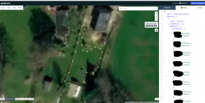
Ich hab mal eben einen Editor getestet. Das ist doch genau das was wir brauchen:
1689349802447.png

Import, Export, Editor, alles dabei (y)

Die Daten sind auch untereinander kompatibel, d.h. man kann jeden Editor benutzen und die gleichen Daten benutzen (y)

https://mygeodata.cloud/converter/ (mit diesem Converter kann man auch .dxf Dateien erzeugen und dann im CAD laden)

Beste Grüße,
Chris
 
Zuletzt bearbeitet:
Alexander Grau ist schon dran! (y)

....siehe in der Sunray App ab v1.0.170 unter Map Data -> GEOJSON ..... dann download
Bedingung ist natürlich, dass Position mode auf absolute Koordinaten eingestellt ist.

Hammer, wie schnell manche Sachen gehen!

Danke dir, Alexander!

Beste Grüße,
Chris
 
Zuletzt bearbeitet:
Btw, es gibt einen Roboter-Simulator (Ardumower/Alfred) welcher auf einem Linux-Computer kompiliert werden kann und ggf. beim Testen von Backends etc. hilfreich ist. Es wird der Roboter simuliert und eine hochgeladene Karte wird abgefahren wie der echte Roboter dies macht. Der Simulator simuliert ebenfalls alle Netzwerk-basierten Schnittstellen (HTTP, MQTT, ...). Die Firmware wird genauso kompiliert wie beim echten Roboter. Die Schritte sind nun hier beschrieben: https://github.com/Ardumower/Sunray/blob/master/alfred/README.md
Das funktioniert schon mal super, hat auf Anhieb geklappt,

Kann ich irgendwie nach dem ich sudo ./sunray ausgeführt habe diese Meldung in der Console unterdrücken:
Code:
BLE: listen
BLE: Failed to create L2CAP socket: Address family not supported by protocol
BLE: Failed to accept L2CAP ATT connection
BLE: run
BLE: l2cap le att listen and accept
BLE: listen
BLE: Failed to create L2CAP socket: Address family not supported by protocol
BLE: Failed to accept L2CAP ATT connection
BLE: run
BLE: l2cap le att listen and accept
BLE: listen
BLE: Failed to create L2CAP socket: Address family not supported by protocol
BLE: Failed to accept L2CAP ATT connection
BLE: run
BLE: l2cap le att listen and accept
BLE: listen
BLE: Failed to create L2CAP socket: Address family not supported by protocol
BLE: Failed to accept L2CAP ATT connection
 
Das funktioniert schon mal super, hat auf Anhieb geklappt,

Kann ich irgendwie nach dem ich sudo ./sunray ausgeführt habe diese Meldung in der Console unterdrücken:
BLE: listen
BLE: Failed to create L2CAP socket: Address family not supported by protocol
Ich habe die Doku mal ergänzt um die Einrichtungs-Schritte für Bluetooth BLE ( https://github.com/Ardumower/Sunray#sunray_alfred => Abschnitt "How to configure Bluetooth BLE module on a Linux computer") - evtl. hilft das schon (man kann dann den Simulator sogar per Handy über Bluetooth erreichen...) - ansonsten schaue ich mal wie ich elegant Bluetooth abgestellt bekomme :) ...
 
Zuletzt bearbeitet:
Ich habe die Doku mal ergänzt um die Einrichtungs-Schritte für Bluetooth BLE ( https://github.com/Ardumower/Sunray#sunray_alfred => Abschnitt "How to configure Bluetooth BLE module on a Linux computer") - evtl. hilft das schon (man kann dann den Simulator sogar per Handy über Bluetooth erreichen...) - ansonsten schaue ich mal wie ich elegant Bluetooth abgestellt bekomme :) ...
Ich habe den Simulator im LXC Container unter Proxmox auf dem Intel Nuc laufen, das Teil hat gar keinen Bluetooth Modul verbaut, irgendwie disablen wäre für mich die Lösung
 
Ok, ich hab eine Compiler-Option in config.h eingebaut (#define LINUX_BLE) welche man auskommentieren kann um BLE unter Linux zu deaktivieren...
 
Tips for CaSSanDRA:
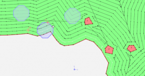
  1. History of points where the mower has failed or collided with an obstacle.
    It would be interesting to know where the machine has failed while it is cutting or at the end of the task. In such a way that you can physically review the points where it has occurred and be able to solve them.

    1689582785045.png
  2. Smoother movement of the ROVER.
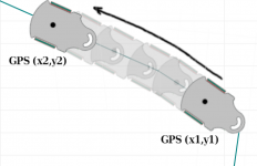
    Wouldn't it be more comfortable to see a fluid movement of the mower by simulating the device from the coordinate point x1,y1 to x2,y2? The software already knows the path that the mower is going to travel, so using a prediction It could make the movement of the icon more friendly and smooth so that you don't see jumps in the viewer.
    1689584642584.pngPerhaps I would have to rectify the movement at each communication (GPS) point between ROVER and the map, but I suppose it is a matter of knowing the speed of movement or calculating an average between the previous points.

These are suggestions that can be useful for me, especially to see the crash points and correct the damage in the grass.

Thank you so much!
Greetings.
 
History of points where the mower has failed or collided with an obstacle.
It would be interesting to know where the machine has failed while it is cutting or at the end of the task. In such a way that you can physically review the points where it has occurred and be able to solve them.
Yes, it will be supported
Smoother movement of the ROVER.
Wouldn't it be more comfortable to see a fluid movement of the mower by simulating the device from the coordinate point x1,y1 to x2,y2? The software already knows the path that the mower is going to travel, so using a prediction It could make the movement of the icon more friendly and smooth so that you don't see jumps in the viewer.
Yes it will be a nice feature, and Plotly supports animations, I already played with that, I also use it in my offline simulations to check the quality of path planner. But it needs refactoring of some pieces of code and remove interval triggering of map rendering, what are big changes for map components. It is possible, and I think I‘ll make it, but not in near future.
 
Zuletzt bearbeitet:
Ich hätte da eine Bitte Bezgl. Des UI:
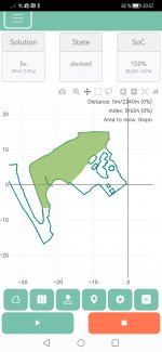
Bei mir, Android, portrait, ist das Vollbild einen Ticken größer als mein Screen:
Screenshot_20230719_205710_com.android.chrome.jpgScreenshot_20230719_205710_com.android.chrome.jpg
Es ist entweder oben die Menüleiste zu sehen, oder unten play und stop.
Meine Bitte: Wenn oben Cassandra, das Steuer-Icon, das I-icon und das Burger-Menü in einer Reihe stünden und nicht in zwei, dann wäre Alles gut.

Viele Grüße,
Jürgen
 
Ich hätte da eine Bitte Bezgl. Des UI:
Bei mir, Android, portrait, ist das Vollbild einen Ticken größer als mein Screen:
Anhang anzeigen 6897Anhang anzeigen 6897
Es ist entweder oben die Menüleiste zu sehen, oder unten play und stop.
Meine Bitte: Wenn oben Cassandra, das Steuer-Icon, das I-icon und das Burger-Menü in einer Reihe stünden und nicht in zwei, dann wäre Alles gut.

Viele Grüße,
Jürgen
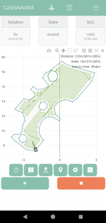
So sieht das hier aus

Screenshot_20230719-213005_1.png
 
@EinEinfach ich habe heute das erste mal meine Karte mittels Cassandra erweitert. Also eigentlich nur eine Ecke konkreter ausgefahren und das Polygon hinzugefügt. Wenn ich die Ecke nun mähen will meldet er nach dem ersten Punkt immer Error no path im sunray log und kehrt zum Docking zurück. Lade ich die "alte" Karte wieder klappt es wieder fehlerfrei.
 
Oben